
A Trail of Ideas
A Photographic Portfolio by Jim
Bones and Todd Jagger
Introduction by Todd Jagger
A Photographic Portfolio by Jim
Bones and Todd Jagger
As the world grows more aware of the unity and similarities among all cultures, and of our kinship with the land that sustains us, El Camino Real provides a symbolic, yet tangible link between the people of two nations, born from a common seed - an idea.
The Sierra Madres and Rocky Mountains are geological brothers forming the backbone of a single continent; the Rio Conchos and Rio Grande are sister rivers, whose waters meet and journey to the sea as one. Within this vast setting an epic drama of human history unfolds.
Whether as stewards of the earth or reapers of its wealth, we are influenced by the land just as the land is influenced by our actions. Our destinies are intertwined. At El Paso del Norte these destinies thread a needle that sews the landscape and its people together. Here cultures blend, and the Rio Grande is both a division between countries and the historic bond of people to each other and to the land. The story of the Camino Real shows that we are not just Mexicans or Americans, but Norte Americanos.
El Camino Real is a "trail of ideas." Just as the first travelers came with ideas of exploration and exploitation, we now travel the Camino Real with new attitudes of mutual cooperation and benefit. The challenges are different, but are likely to be as difficult as any encountered by those men, women, children and animals, whose feet literally wore a groove in the earth over a thousand miles long, crossing the Tierra Adentro.
Mexico
Photographs and Text by
Todd Jagger
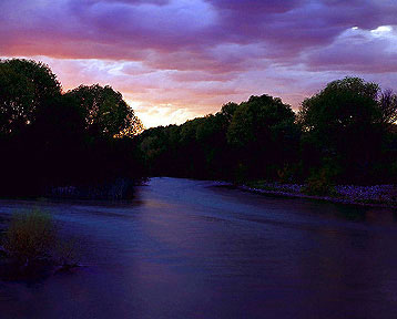 Rio
Conchos at San Francisco de Conchos, Chihuahua, México
The final moments of sunlight reflect upon the last large, free
flowing body of water early travelers along El Camino Real encountered
until the Rio Bravo del Norte (Rio Grande), hundreds of miles away. In
this vicinity in 1598 Don Juan de Oñate encamped his massive expedition,
including several thousand head of livestock, to complete the King's audit
by the royal inspector. Lined with cottonwood and seepwillow, the deep
swift river winds through low, undulating hills of the Valle de Zaragoza,
now extensively cultivated.
Rio
Conchos at San Francisco de Conchos, Chihuahua, México
The final moments of sunlight reflect upon the last large, free
flowing body of water early travelers along El Camino Real encountered
until the Rio Bravo del Norte (Rio Grande), hundreds of miles away. In
this vicinity in 1598 Don Juan de Oñate encamped his massive expedition,
including several thousand head of livestock, to complete the King's audit
by the royal inspector. Lined with cottonwood and seepwillow, the deep
swift river winds through low, undulating hills of the Valle de Zaragoza,
now extensively cultivated.
From here the Camino Real followed and crossed several tributary streams,
including the Rio San Pedro and Rio Chuviscar, in its northward course
towards the mountains surrounding present-day Ciudad Chihuahua. Parajes,
or camps, were also made at Hacienda Bachimba before entering the Chihuahua
Basin.
Sierra Santo Domingo, Chihuahua, México The effects of seasonal rains paint a brief, lush green over the harsh desert mountains just southeast of Ciudad Chihuahua. Ocotillo, agave, lechugilla, creosote bush, acacia and other desert plants are at peak following the intense thunderstorms of late summer. The weathering effects of heavy downpours are visible in the steep arroyos carved into this relatively soft rock. Like most of the ranges in this region, Sierra Santo Domingo is composed of limestone with igneous intrusions, resulting in the formation of silver, lead, copper and other mineral ores.
By the time Oñate and his caravan reached this area in 1598,
minerals had been exploited at Santa Barbara, to the south, for over thirty
years. As the wealth of the mountains was later tapped, Chihuahua became
the most important settlement in northern Mexico and the hub for trade
with the interior lands.
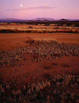
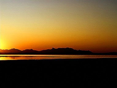 Laguna de Patos, Chihuahua, México
Predawn is still and quiet by Laguna de Patos, named for the ducks that
frequent its waters north of Villa Ahumada. The faulted mountains of Picachos
de Altaparras, in the background, are actually many miles away. Only a
few feet at its deepest, this deceptively large body of fresh water grows
and shrinks with the seasons. At times the lake bed may be hard and cracked,
void of grazable grasses, the laguna concentrated by evaporation into an
undrinkable saline solution. At other times many square miles are covered
with a few inches of "sweet" water, surrounded by a sea of grasses.
Laguna de Patos, Chihuahua, México
Predawn is still and quiet by Laguna de Patos, named for the ducks that
frequent its waters north of Villa Ahumada. The faulted mountains of Picachos
de Altaparras, in the background, are actually many miles away. Only a
few feet at its deepest, this deceptively large body of fresh water grows
and shrinks with the seasons. At times the lake bed may be hard and cracked,
void of grazable grasses, the laguna concentrated by evaporation into an
undrinkable saline solution. At other times many square miles are covered
with a few inches of "sweet" water, surrounded by a sea of grasses.
After leaving Chihuahua, water became the primary consideration for
travelers. Though not abundant or close together, springs and intermittant
streams at Sacramento and El Sauz ("the willow") provided dependable
water for great herds of livestock. Laguna Encinillas, larger and
more stable than Laguna de Patos, although more brackish, was surrounded
by springs. From there north, water was scarce. A spring at Sierra
Gallego was the last source travelers encountered before the parched Jornada
de Jesus y Maria, an arduous march over sixty waterless miles to Ojo
Caliente, the hot springs near Carrizal, and Laguna de Patos.
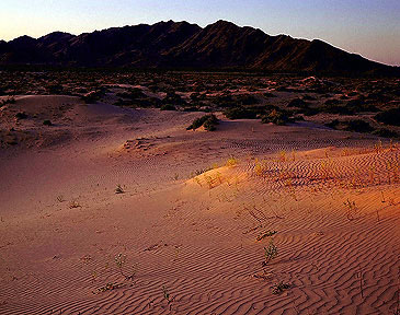
Médanos de Samalayuca, Chihuahua, México Daylight fades and the médanos, or dunes, of Samalayuca south of Ciudad Juárez, are cast in a benevolent light. One of the largest areas of shifting sand in North America, they are the remnant of a huge fresh water sea, greater than Utah's Great Salt Lake, that formed and drained during the last ice age. On the constantly moving and blowing dunes, sparse vegetation of creosote bush, catclaw acacia, sage mesquite and bindweed cluster together to gain a tenuous foothold in an ever changing landscape.
As difficult as the dry Jornadas were for travelers along El Camino
Real, the Médanos de Samalayuca were perhaps the most formidable
barrier they encountered in their journey. Usually half of the great carretas,
or carts, were left behind while double teams of oxen and mules pulled
the remainder through the soft underfooting with great difficulty. The
crossing was often made by night to avoid the intense heat of day, and
the possibility of Indian attacks. Travelers would veer many miles from
their intended course to traverse the dunes at the narrowest point. From
there the trail led through the Sierra Presidio at Puerta Presidio, a doorway
through the mountains, to the Rio Grande, and then followed the river upstream
to El Paso del Norte.
The United States
Photographs and Text by
Jim Bones
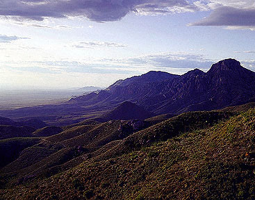
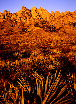 Organ Mountains, Las Cruces, New Mexico, USA
Yucca, sotol, prickly pear cactus, creosote bush, acacia and
sparse cover the rocky foothills of the Organ Mountains. Throughout
the region prominent ridges like this, clearly visible to travellers for
many days, became well-known landmarks. Their features, recognizable
from earlier travellers' tales, provided comfort and direction to settlers
crossing the unknown uplands and arid plains of the great Chihuahuan desert.
These strange plants and fantastic landscapes were unlike anything they
had seen before, and inspired both terrible awe and sublime ecstacy.
Organ Mountains, Las Cruces, New Mexico, USA
Yucca, sotol, prickly pear cactus, creosote bush, acacia and
sparse cover the rocky foothills of the Organ Mountains. Throughout
the region prominent ridges like this, clearly visible to travellers for
many days, became well-known landmarks. Their features, recognizable
from earlier travellers' tales, provided comfort and direction to settlers
crossing the unknown uplands and arid plains of the great Chihuahuan desert.
These strange plants and fantastic landscapes were unlike anything they
had seen before, and inspired both terrible awe and sublime ecstacy.
Early caravans on the Camino Real crossed the Rio Grande at El Paso
del Norte, between Monte Cristo Rey and Sierra de la Otra Banda, and followed
it upstream on the east bank through a wide valley to parajes Salinera
and Canutillo. The trail continued west of the mountains to Mesilla,
then looped around the Dona Ana Peaks and descended to paraje Roblero,
the last river camp before the dreaded Jornada del Muerto.
Jornada del Muerto, near Engle, New Mexico, USA A full moon rises of the San Andres Mountains, volcanic hills, cracked playas, bunch grass, tumbleweed and mesquite of the Jornada del Muerto (Journey of the Dead). Millions of years ago this empty expanse was a pathway for the ancestral Rio Grande. Long since abandoned, it now forms a bolson, or huge rock-filled basin, where most of the rain that falls runs to the center, and sinks or evaporates.
North from Robledo lay paraje San Diego, where the trail departed east of the river, and entered the Jornada del Muerto. For ninety fearful miles of mostly forced night march, through parajes Perillo, Laguna del Muerto, and Tusas, to paraje Fra Cristobal, there was no reliable water, escape from the dusty winds or protection from hostile Indians.
Another difficult day over dry arroyos and rough lava flows brought
the caravans to the river again at the base of Contadero Mesa. In
this place the foothills and river crowd close together, forming a narrow
passage where livestock could be gathered and recounted.
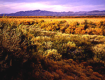
Bosque del Apache, San Pedro, New Mexico, USA Bosque forests of cottonwood, willow, salt cedar and cattail, bounded by mesquite, saltbush, chamisa and sage, cover the broad Rio Grande flood plain. Arrival at the bosques meant not only much needed water, but also abundant game, fuel and forage for livestock. Mesquite, now the most conspicuous trail indicator, migrated north through Mexico on land hard grazed by millions of imported sheep, goats, cattle and horses. Today traces of El Camino Real still linger as invasive vegetation between sandy hills and thickets of salt cedar.
From Contadero Mesa the route remained close by the river as it passed
many campsites, such as Bosque del Apache, Sabino, La Joya de Sevilleta
and Casa Colorado. Some of these parajes were destined to
grow into lively villages, others to simply melt back into the sands of
the Rio Grande valley. North, beyond Bosque de Isleta, the early
route continued east of the river, below the Manzano and Sandia Mountains,
through what is now the metropolis of Albuquerque, to Pueblo Sandia.
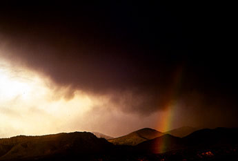
Sangre de Cristo Mountains, Tesuque, New Mexico, USA Thunderclouds and a rainbow arch over the aspen, oak, maple and evergreen covered ridges of the Sangre de Cristo Mountains. High peaks make their own weather, and in this desert region hold promise of water, forests, and alpine meadows. These simple riches far outweigh all the jewels and precious metals sought by the conquistadors. They are the real natural treasures that enabled the early colonies to prosper and thrive.
The way from Sandia Pueblo led up through the fertile Bernalillo valley, to paraje Angostura, and the Pueblos of San Felipe and Santo Domingo. Travelers then detoured northeast, to avoid the engorged Rio Grande, and with great effort, climbed the steep volcanic escarpment at La Bajada, to Las Golondrinas and El Alamo. Near its end, the Camino Real crossed rolling, treeless plains by Agua Fria, before descending to the shaded Pueblo valleys of Tesuque and Pojoaque. Finally, the Royal Road continued a little upriver, where in 1598, near San Juan Pueblo, Don Juan de Onate established San Gabriel as the earliest official settlement in Nuevo Mexico. Twelve years later, at the foot of the Sangre de Cristo Mountains, Santa Fe was founded as the first Royal City, and capital of all the northern lands.
Conquest and religious oppression resulted in Pueblo revolts, which in 1680 drove European settlers back to El Paso del Norte. Following reconquest in 1692, Santa Fe was again occupied as the capital of New Mexico and eventually became a fabled trading center at the northern end of the Chihuahua Trail.
Conclusion by Jim Bones
These images offer a broad view of the continually changing terrain linked by El Camino Real in northern Mexico and the southwestern United States. They celebrate the natural spirit of this land as it may have appeared at the time of the European settlement, and affirm a sense of belonging to a place that has become our common home.
In spite of the immense territory involved, locating pristine places to photograph proved to be a difficult task. European settlers introduced new ways of mining, lumbering, farming and grazing on dry grassland, which led to rapid exhaustion and severe erosion of vulnerable soils. Therefore, present day landscapes bear only a dim resemblance to the wild mountains, wooded valleys and arid plains of early Post-Columbian days.
To find these remnants of the original environments required working around widespread effects of agricultural activity and the clutter of industrial development. Unavoidably, these photographs also record the presence of introduced plants like Central American mesquite, Mediterranean salt cedar, and Russian tumbleweed.
In less than four hundred years, ruts from hooves, feet and simple wooden wheels have grown enormously, into railroads, interstate highways, microwave towers, power lines and contrails that fill our vistas today. Although altered in form, El Camino Real remains an avenue for ideas as well as commodities. The information and attitudes it conveys will continue to shape this land and its people for centuries to come.
The old trail of ideas can carry attitudes of mutual trust, respect,
cooperation, and responsibility for this shared region, thus ensuring the
continuation of the finest traditions, both wild and human, for living
on this starkly beautiful part of the earth.
The El Eamino Real
Limited Edition Photographic
Portfolio
The photographs and text on this page are taken from the El Camino Real Limited Edition Photographic Portfolio, a stunning presentation of eight original dye transfer photographs. The handmade dye transfer prints each measure approximately 16x20 inches and are archivally matted to 22x28 inches. The portfolio comes in an attractive handmade portfolio case with hand-silkscreened historical introduction and map/caption sheet. Each print and overmat is signed and numbered by the photographers.
The portfolio was originally intended for a limited edition production of 50 portfolios, however because of the discontinuation of the dye transfer process by Eastman Kodak in September of 1993, the production was limited to an edition of 25 portfolios due to the unavailability of materials to produce the prints.
Individual prints are not available and when the portfolio edition is reached the printing matrices will be retired and no more prints made from them.
Publisher's Note (2008): The El Camino Real Portfolio has been was a resounding success. The portfolio has been exhibited widely throughout
North America, including locations such as the Museo del Arte (Juarez,
Chihuhua, Mexico), the Mexican Cultural Institute (Washington, D.C.) and
the Institute for Texan Cultures (San Antonio, Texas). The photographs
have been published in El Palacio Magazine and the Santa Fean Magazine.
Purchasers have included prestigious law firms, the Hoteles Camino Real,
and executives with the Microsoft Corporation. There are currently no portfolios for sale from the artists.
Update 2012: We are informed that the El Camino Real Portfolio is on permanent display at the El Camino Real International Heritage Center near Socorro, New Mexico! (http://www.caminorealheritage.org) We are delighted that our work has been included in this international site so visitors can enjoy the original prints.
Also... I realize that this web site was created before we had access to really good scans of the 4x5 transparencies. Suffice to say these scans really don't do justice to the images. I'll see what I can do about that... -todd